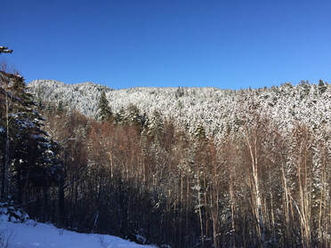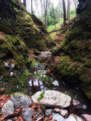
So began my relationship with a mountain.
While Shepody’s distinct presence has been appreciated for generations by locals and visitors alike—and many with more history than me—what remained with me was the intimacy of that snowy hike. Since then, my husband and I have explored the mountain in all seasons. We’ve discovered carpets of spring flowers, fox dens, a nesting turkey vulture in a cave, moss-covered ravines and small waterfalls.
No matter whether traveling a maple ridge in the glory of autumn, puzzling over tracks in the snow, photographing wildflowers in spring, or simply sitting on the trunk of a toppled tree listening to birds or watching for wildlife, each and every time, I absorb something new. The mountain is a good teacher.
Inspired by the work of the Elgin Eco Association, which was instrumental in creating the Mapleton Acadian Forest Nature Preserve near Elgin to a save a 160-acre forest destined for clearcutting, I often wished for a means to protect this special place, Shepody Mountain, from any threat of commercial logging.

Compiling the justification was an opportunity to learn more about Shepody’s geology (it’s older than the Rockies!), history and its connectivity value as a wildlife corridor between other conservation areas. It was also a chance for people to put into words their own relationship with the mountain. We heard about hikes and hunting, snowshoeing and skiing, picnics and overnight campouts. We learned how memories of people who have died are revived during trips to the mountain. We heard how ancestors logged the slopes with horses, and that the remnants of a sawmill can still be found along Hamilton Creek.
Dawne MacLean related a special community bonfire event in September 1916 to recruit soldiers for World War I. “This historic event shows that Shepody Mountain has always been revered as a towering icon of inspiration and strength,” she wrote.
Marjorie Henwood told how, 35 years ago when she and her husband first began hiking the mountain, Merrill left a jar with a notepad and pencil inside for visitors to sign when they reached the summit. “There were thousands of signatures over the years. People from Sweden and Germany…all over.”
Josh Thibodeau from Weldon wrote that, “I’ve thousands of hours taking groups [to Shepody] to do all kinds of different activities; from trail building, mountain biking, hiking, snowshoeing, backcountry skiing and snowboarding. I’ve also worked closely with the local landowners to ensure that we keep the mountain clean and natural.” He says the neat part about trail-building is noticing how wildlife will then travel those trails.
It became clear how inextricably intertwined we are to place...how, despite the automated society we live and work within, a bond with our environment remains that can be revived by a trip to the woods. In protecting special places, we’re also preserving relationships and memory.
Shepody consists of both Crown and private land, so respect and appreciate the willingness of landowners to welcome visitors to the mountain. Adhere to private or no trespassing signs, do no damage, and leave no trace (carry out your garbage!).
The main access off Route 114 (45°47.911N, 064°36.938W) is an unmarked, unmaintained road across a field. It borders private land, so it would be prudent to seek permission to cross, and to park without restricting access or creating an obstacle.
While Shepody looks like a mild hump of a mountain, her contours are far from gentle, and the rewards of the hike are only gained through effort. Prepare well and travel safely. A number of old logging roads cross the mountain, as well as bike paths and game trails, but none are marked and there are no maps. A few geocaches are located on Shepody as well. If unfamiliar with the trail network, it’s strongly advised that you travel with a knowledgeable guide, carry a GPS, or have a good sense of direction and a willingness to explore.
Remember, this is not a park, but a wild, unmonitored area. Maintain a healthy respect for and distance from wildlife, such as coyote, moose and bear. The area is frequented by hunters in hunting season, so be watchful for snares, keep pets on leash and wear bright orange.
The trail to the 320-m summit is approximately a 9-kilometre loop and begins by winding around the back of the mountain in a gradual ascent. It crosses three creeks (two of which have no bridge crossing), and then begins a strenuous climb. A number of smaller roads branch off the main one, one of which bears right to the Chemical Road. The summit trail bears left.
Once reaching the summit, as identified by the monument (45° 47.942N 064° 38.402W), the trail drops into a hollow, then climbs again towards the east, reaching a dirt road constructed on private land which brings you back down the east-face by Route 114. Most hikers descend on this road, which affords beautiful views of Grindstone Island and Mary’s Point, but you can also follow bike trails to the bottom. Always be conscious of bikers.
For more information on Trails, see Exploring Our Trails.
 RSS Feed