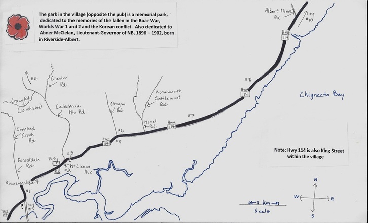
Head up Hwy 114 into village. Park at the drugstore (5883 King St on your right). The cemetery is tucked in behind. Roughly 151 stones, 224 names. Oldest stone may be 1833.
¥ Peck Burial Ground (2)
Head east on Hwy 114 2.2 km to McClenan Ave. Turn right – it’s OK – it looks like you are going into someone’s house, but it is a right-of-way. Go to the end of this dirt road and park. Walk down the path (keep to the left) for 200-300 m. About 8 stones. Abiel Peck, buried here, died in 1802. Keep walking down the path to arrive at a beautiful clearing that overlooks the river and surrounding area.
* Riverside (3)
Head east on Hwy 114 2.6 km. to the intersection of Caledonia Mountain Road. The cemetery is on the right. Roughly 60 stones, 106 names. Oldest stone from late 1840’s.
* Caledonia Mountain (4)
Turn left at Caledonia Mtn Rd (see #3). Go about 10.5 km north. It’s on roadside on the right, about 3.6 km past the TV tower. 28 stones, dating back to 1841. Foundation of the old church is still there.
* Hopewell (5)
Head east 5.1 km. Cemetery is on the right. Almost 400 stones. Oldest stone dates from 1832.
* Holy Ghost (6)
Opposite the Hopewell Hill cemetery (5). 75 stones. Relatively recent burials. All date from 1940’s.
# Shepody (7)
5186 Hwy.114. The sign got broken off in the winter, so watch the numbering. This is 7.6 km from the museum. 119 stones, starting early 1800’s. There is a faded plaque with a listing of people in here. You can read plaque but the rest of the cemetery is very overgrown.
¥¥ Daniels (8)
From Shepody Cemetery (7), head towards Hillsborough, drive 2.6 km. Park your vehicle by the "Shepody" sign. Face the woods. Walking path is on your right. Walk 125-135 paces up the path then take a left in the field. Take a couple of steps and again take another left. Walk straight ahead, a metal fence should be visible. 9 stones, dates back to 1841. Very overgrown.
* Mountain View (9)
Hwy 114, 2.5 km south of the road to the Rocks (15.1 km from the museum). Behind Lower Cape Baptist church. 262 stones. Dates back to 1810. Includes stone for Tom Collins, convicted and hanged for murder, 1907.
¥ Calhoun-Dickson (10)
Established circa 1800. From #9,drive north on Hwy 114 to The Hopewell Rocks Hotel. On the right hand side by Craft Barn, down a small slope in back is the cemetery. Best to ask at Craft store. 11 stones. Oldest 1803.
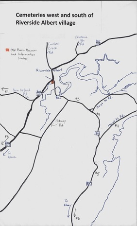
| West ¥ St. Agatha’s (New Ireland Catholic) (1) Stay on Hwy. 114 for 1.7 km to New Ireland road, marked and on your right. Go 15.4 km. This is a rough, gravel road. Cemetery is on your right. The church, which no longer exists, was across the road (you can see foundation). 74 stones, dating back to the early 1800s. ¥ Germantown (2) Go 6.7 km west on Hwy 114 from the museum. Access road in is on your right – just a dirt road. Sign is not easy to see. Cemetery is 50 m up that road. The old Germantown Baptist Church stood on this property but was pulled down. 21 stones, dating back to 1851. South # Stevens (3) Established 1808, last used 1836. From museum, take Hwy. 915 for 2.6 km. Cemetery is on your left and is small and hidden. If it’s overgrown, it will be very difficult to see. 5+ stones. # Harvey Methodist (4) From Stevens (3), continue 1.1 km on Hwy 915. This cemetery is set far off the road on your left hand side. There are only 8 stones, dating back to 1838. # Ha Ha (5) At the museum, take Hwy 915 for 7.6 km. Cemetery is on the left. There is a little pullout for parking and a picnic table. Very pretty. 26 stones, dating back to 1817. * Waterside United Baptist (6) From museum, 19.4 km along Hwy 915. On right hand side. 166 stones dating back to 1837. There is a plaque beside it, commemorating the church that stood there. The church was struck by lightning and burned in January 2012. * Bayview (7) Charmingly well-tended. At the museum, take 915 3.6 km then turn left on Mary’s Point Rd. Cemetery is another 5.5 km, on left. (There is another way to access, but this is a beautiful drive). 269 stones, dating back to 1814. Yes, there are at least 2 other completely overgrown cemeteries in New Horton but the access roads are also completely overgrown (impassable) and the cemeteries themselves are on private property. There are also two cemeteries primarily with Keiver names on the stones in the area. If you want this information, look at the sources listed below, because these two cemeteries are also overgrown and inaccessible. | Dates are approximate, depending on ability to decipher the stone! Thanks to: Beulah Morrissey, Bill White, Myrna Stewart, Helena Lewis’s website (http://freepages.genealogy.rootsweb.ancestry.com/~mhlewis/new_brunswick_cemeteries.htm) and “Cemeteries of Albert County” compiled by David Christopher. Written and illustrated by Susan Quinn, 2014. |


 RSS Feed